Monday, November 30, 2009

Macaronies, life and death and glaciers. Sunday, November 29


This morning we see macaroni penguins from the zodiac. For a few reasons (including breeding fur seals on the beach--very nasty, territorial males--we can not land on the beach. Penguin species count is at six. The zodiac cruise includes checking out a few other coves along the coast with fantastic rock formations. They look like something out of a fantasy novel.


We do land on a different beach in Cooper Bay and find a dead elephant seal being pecked at by skuas and giant petrals. The giant petrals really have the vulture niche in South Georgia. They even have same behaviors--charging with out stretched wings, tail in a vertical posture, getting their whole head into the carcass.

One of the king penguin chicks seems to be desperate for food. Keeps going up to anything (including people and tripods) begging for food. We take a hike up a snow field looking for albatross nests. No nests but a great walk.


The afternoon is a zodiac cruise up the very narrow Larson Harbor. This is a scenery excursion, not wildlife. It was amazing. Later, the ship cruises up Drygalski Fjord to the tidewater glacier at its head. To leave, the captain uses the bow and stern thrusters to pivot the ship.


In the wrap-up before dinner under-water videos from the ROV--some cool, strange things live on the floor of the ocean here. Also a song by one naturalist about krill--”All you need is krill.” (think Beatles)

West side of South Georgia, one million. Saturday, November 28.


Our first stop is at Gold Harbor on South Georgia. Staff had offered a landing before sunrise at 5:00AM (for the photographers who are looking for that “magic light”) but it was cloudy and raining. Rain stopped and we were on the beach by nine. Elephant seals, fur seals and king penguins. Lots of king penguins. The noise from the adults and the chicks were amazing. There were the creches of brown fluffy chicks making songbird like calls--waiting for mom or dad to come back and regurgitate a meal. The sailors who first saw them referred to them as “the okum boys” because they looked like the rope and tar caulk called okum that was used to fill cracks in ships. They look like a sea of brown with a black and white and orange adult scattered among them. I think I shout 400 pictures before I just put the camera away and just watched. The penguins (adults and chicks will walk to about two feet from you. If you sit down by a wiener seal (the young elephant seals) it is not unlikely they will come over and try to nurse you boot or your knee.


“The Government of South Georgia” is serious about enforcing the regulations for tourists. This site is has video surveillance from a number of points of view to insure tour groups stay out of restricted areas (sensitive animal habitats)

Much of the land beyond the beach is covered by tussoc grass. It is a challenge to walk through. Bev did and climbed a ridge to see a albatross nest with chicks. (She still needed binoculars).


Oceanites doesn’t count king penguins (not in their study plan) but Ron notes that they would be very hard to count. While the brush tail penguins (chinstrap, Adelie and gentoo penguins) all mate at the same time and the chicks leave the nest before winter, kings are on a 18 month breading cycle. Many times you will find single molting penguins, chicks, and pairs incubating an egg, all at the same colony.


In the afternoon we head to St. Andrews Bay. Elephant seals, fur seals, king penguins and reindeer. No tussoc grass at this location (the reindeer graze to the ground. We head off to the south following a naturalist. Go up a ridge and look down on the largest colony we’ve seen. Over 400,000 king penguins. The largest colony of kings on South Georgia. We have now seen over one million penguins.

While I’m writing this in the ship library, I’m watching four snowy-sheath-bills out the window. White birds about the size of a pigeon, a face sort of like a chicken and at first glance appear rather dumb and clumsy. But they are checking everything out. Pulling on wires, pecking at latches, tugging at straps (all on top of the enclosed life boats). They also are very coordinated--just saw one land while going backwards.

snowy sheath bill.

At sea, bio-sanitizing and South Georgia Island. November 27.

After breakfast we all attend a required briefing on South Georgia. South Georgia is part of the United Kingdom and administered from government offices in the Falklands. We see a video by “The Government of South Georgia” (that seams kind of a strange term since the only people who live here are the staff of two small U.K. research stations). The basic message is “we are really serious about not bringing in any more exotic plants or animals and we are really serious about protecting the wildlife.” It also has some safety warnings, like “stay away from fur seals!” (punctuated by a picture of a person’s hand after being bitten--you can see pieces of finger bones.) Exotic species currently on South Georgia include a beetle, reindeer (introduced by the whaling industry to provide fresh meat), dandelions, and the Norway rat. Since the birds on South Georgia evolved with no land predator, they have started to eradicate the Norway rat.


After seeing the video, we are all required to go through bio-sanitizing. This includes have all our outerwear inspected--and camera bags and pockets vacuumed out. They pay particular attention to checking for seeds stuck in Velcro. (This is our second bio sanitizing--our first was before we set foot on any antarctic island.) As with Antarctica, we step in a disinfectant before leaving the ship and when returning from the ship.


To kill the time, another naturalist talk--an introduction to South Georgia. Did you know the South Georgia Pintail is a vampire duck? It will eat the blood from the wounds on seals.


Our first stop on South Georgia is the caves at the inlet to King Haakon Bay where Shackleton first landed when they reached South Georgia. We then head into the bay and take the zodiacs ashore at Peggotty Bluff--the final stop for Shackleton’s long boat and where he and two crew headed across the island (over a mountain range and glaciers) to find help at a whaling station on the other side.


Onshore the first thing you notice is that there are green plants (besides algae and lichen). The second thing is elephant seals. The pups that have just been weaned (“weaners”) are really cute with hugh black eyes. The adults are really ugly. We walk up a stream of glacier melt water. There is an alluvial plane of the rock powder created by the glacier as it slides down the mountain. It looks like a small version of the alluvial planes you see in the Japer park area in Canada. There are a couple giant giant petrels(birds) fighting over the remains of a dead seal--petrels fill the vulture niche at South Georgia.


There are about a dozen king penguins molting by the beech. The first king penguins we’ve seen.

Back on the ship, “the photography department” (Ron and Flip) have invited anyone with a laptop to create a three minute slide show sampling what they’ve shot so far. Some really impressive photography. Some really cool ideas I’m going to steal. We just didn’t seem to have the time to put a slide show together.


Oceanites also announces the winner of “how may penguins have we seen so far” contest. The winner was only 32,000 penguins off. So far, we have seen over 402,000 penguins (I was way off--I guessed 15,000)

  • 224,000 Adelies,
  • 18,000 gentoo,
  • 160,000 chinstrap.

Friday, November 27, 2009

At sea, a little rock’n and roll’n, More talks, Thursday, November 26 (U.S. Thanksgiving Day)

We are at sea all day today, headed for South Georgia Island--on the open ocean. More naturalist/staff talks to keep us out of trouble.


The first talk of the day was about the Shackleton Expedition in the early 1900s. More talk about ships getting caught in ice, ships being crushed by ice. Shackleton had taken the long-boats from his ship, his crew pulled them across the surface ice, launched them and got to Elephant Island. This is the island we spent much of yesterday trying to get through the pack ice to see.


The second talk was about plate tectonics. The talk started by noting that a 17th century Anglican bishop had calculated the exact date God created the earth--on a Saturday, 4004 BC, at sunset. (A couple sarcastic notes--would god work on the Jewish Sabbath? at sunset where? He calculated it using the bible and “other sources.” That the extreme fundamentalists pin their belief of a “young earth” on a calculation made in the 17th century Anglican bishop is beyond me. (The talk then explained plate tectonics and how Antarctica ended up at the southern pole and why it has been stuck there.)


Next talk is 10 tips for improving travel photography with Rolf Hopkins (the Lindblad staff photographer on board). If I get around to it, I’ll write a post specifically about his talk. As a teaser, two bonus tips are:

“If you want to take better photos, stand in front of better stuff.”

“Find the best light and shoot what’s in it.”


Happy Thanksgiving Day in the U.S. Dinner options included a traditional turkey dinner. I had the grilled salmon.

Wednesday, November 25, 2009

Trying to get to Elephant Island, Wednesday, November 25

We were woken up be things falling off shelves. The sea is getting rougher.


We’re trying to get to Elephant Island--where Shackleton’s crew overwintered The island is surrounded by pack ice. Spent the morning moving around trying to find an opening in the ice, through the fog.


We came up on two humpback whales, followed them for a while. After the captain turned back to finding a way through the ice, the whales stayed with us for about 20 minutes more. The sonar indicates a concentration of just below the surface. The whales were eating without have to go deep


Just announced--the pack ice is too extensive. It is a mix of surface ice (OK kind of ice) glacier ice (you really don’t want to hit with a ship), multi year ice (also a no-no). We can not find a way in that would also guarantee us a way out. So we are abandoning our attempt to get to Elephant Island.


On our way to the South Orkneys, the bridge spots five fin whales-the second largest of the baleen whales. Spend about half an hour watching them, the are doing very shallow dives.


Tonight, the first showing of a new Lindblad movie, “Counting Penguins.” It is about Oceanites, the only non-governmental research group working in Antarctica. More about Oceanities in a future post.


Late update. We are skipping the South Orkneys--today’s ice report shows even more ice around the South Orkneys than around Elephant Island. So we will get an extra day on South Georgia. You have to be flexible when on a Lindblad trip. They take advantages of changing conditions with quite a few changes in plans.


Walking on ice--this is a big deal?? Dumb human tricks. Traveling north Tuesday, November 24

Another chance to walk on sea ice. I decide--big deal, walking on ice. It turns out there were seals on the ice and it was warm. Oh well, i got spent a relaxing morning on-board.


The other activity this morning was another polar plunge. Since the law that requires Minnesotans to play “hardy Minnesotan” anytime they are out of state only requires one polar plunge per trip, I again stay on board. Turns out is was much warmer and much more pleasant that the first one. But it was still a polar plunge!


After crashing into the ice again for a marketing shot (we left the photographer on the ice), we head north, destination Elephant Island sometime tomorrow.

We cruise by an emperor penguin siting on broken sea ice with five Adelie penguins. The ship

does a U-turn and slowly creeps up on the penguins. Most of the passengers put on parkas and head for the bow--in a stiff wind driven snow. Didn’t get too close, and the emperor never stood up. It is clearly much bigger than the Adelie penguinsThe ship backs away and turns back on coarse.


We have three talks by staff in late morning and afternoon. One about the ice and climate of Antarctica. One on the history of Antarctica discovery, starting with the ancient Greek predictions of a southern continent. [Interesting note of strange symmetry--the Arctic is an ocean surrounded by continents and the Antarctic is a content surrounded by ocean.]


The last talk is a quick history of whale photography by Flip Nicklin the National Geographic photographer who is on the cruise. Flip IS the history of whale photography.

  • His father owned one of the first dive shops in Southern California and was given an underwater still camera and underwater 16 millimeter film camera. He shot the first underwater still pictures and film of a whale in the early 1960s.
  • Flipp has done 19 feature photography articles for National Geographic, 17 on whales and dolphins.
  • He was involved in the early whale research that used photography of flippers, fins and flukes to identify and track individuals.
  • He photographed the first hydrophone research of whale song. [Interesting note: Whales were first protected in 1966 but National Geographic did the first whale story that didn’t treat whales as an economic commodity until 1971.]
  • When doing whale work, he assumes he works on site 100 days, actually gets on or in the water 70 of those days and that all the useful pictures come from just four days.


There seems to be a preoccupation on this ship with ships being destroyed by ice. There are a number of books about the Titanic, the Lusitania and Shackleton in the library, books about the Titanic and the Lusitania and a Shackleton DVD for sale in the gift shop. During the recap tonight, naturalists tell us about how “growler” ice warned sailors of icebergs nearby and read first-hand stories of sailing ships being crushed by icebergs.

Rounding the tip of the Peninsula, Antarctic Sound and Weddell Sea. Monday, November 23


We’ve been sailing northeast all night and this morning are rounding the northwestern tip of the Antarctic Peninsula. Heading through the Antarctic Sound we go between a very large tabular ice burgs. (Tabular as in “Table”) These are huge, flat pieces of ice shelf. Many are bigger than multiple city blocks. Standing on top of the deck above the bridge, you can just barely see over the top of them--That makes them 23 meters high (about 75 feet)--that’s above the water, over 200 meters (over 2 football fields) is below the water. There is no comparison to the broken sea ice (about 2 meters thick) or Ice burgs we’ve been going through.

The tabular ice burgs are big pieces of the Antarctic ice shelves that have broken off. An ice shelf is formed when a land glacier slides out into a protected sea or bay and starts floating instead of breaking off near land. This forms and ice shelf. The tabular ice we’re seeing are from the Larsen, Ronne and Flichner ice shelves. A normal ice burg is formed when a glacier breaks off (calves) at the sea edge. Broken sea ice is the remnants of a section of the sea that froze (think lake ice).

[Note: this is the life, writing this while headed to Elephant Island, having a mocha, listening to Victor play Girshwin’s “Rhapsody in Blue.”]


We land at Brown Bluffs--a landing on the continent that includes Adelie and gentoo penguins. Lots of Adelie penguins here. Selected a rock as close to the 15‘ limit as possible with as little guano as possible and sat and watched penguins for half an hour. Took a few pictures but mainly watched. Watched penguins adjusting their eggs, watched penguin pairs greet each other, watched penguin sex, watch penguins build nests with small rocks, watched penguins steal rocks from their neighbors nests.

Back on the ship and we head into the Erebus and Terror Gulf of the Weddell Sea. Actually quite calm (the gulf is really named after two British “bomb” ships that had been converted to research vessels). We are the first non-icebreaker in the Weddell Sea this season. We end up with the ship stuck bow first into fast ice (on purpose) for the night. See our first emperor penguin of the trip (we weren’t planning on seeing any, they are just leaving their nesting area quite a bit south of us.). You can make out it’s markings in the birding scope. Our fifth penguin species (including the Galapagos Penguin). Only 12 to go.

Today we heard a talk by Ron Naveen. the founder and Executive Director of Oceanites. He and two of his staff are on board doing penguin censuses at each of our stops. I think Ocenites deserves their own blog post.

Tuesday, November 24, 2009

More penguins, some Antarctic history and the continent. Sunday, November 22


They’ve split the passengers into 4 groups with only three on shore at a time (to follow the Antarctic Treaty guideline of only 100 tourists on land at a time). Today for the landing we were in the group that started with a zodiac cruise among the Icebergs. It’s a cloudy gray day so the Icebergs aren’t the fantasic blue color but are some fantastic shapes.

We next head to a Gentoo penguin colony on Pleneau Island. (I think I may be getting a little tired of penguins!.) I decide sit and watch the penguins hopping in and out of the water. Fascinating. Bev decides to stay a little longer and I take a zodiac back to the ship. Of course that’s when a Leopard Seal swims up and starts checking out penguins for lunch. According to Bev, the penguins immediately move away from the beach--rapidly. [Sarcastic note to Apple--how about naming the next operating system and updates after seals?]


In the afternoon we head to Port Lockroy. This was an anchorage used by explorers and whalers. In World War II, the British built a small outpost on the very small Goudier Island that was part of a secret British project to monitor German shipping movements during World War II. Seven people would overwinter here. After the war, the base was used for civilian science until 1964. It is considered a historic Antarctic site and has recently been restored by the United Kingdom Antarctic Heritage Trust as a museum and Gift Shop (They accept Pounds Sterling, US Dollars, Euros, MasterCard and VISA).


Four people staff the station during the summer tourist season. They live in rather primitive conditions--not unlike the conditions the crews when the station was operating. (Although they do get to shower on board cruise ships they are invited aboard.) They are also limited to a very small Island that also has lots of penguins--and therefore lots of penguin guano--I wouldn’t want to be hear in February after a summer of nesting penguins.


We also visit Neko Harbor for a landing after dinner. Up until now, all of our landings have been on islands in the Antarctic Peninsula archipelago (Geologically and geographically part of the continent). This landing however is on the Antarctic mainland. If we wanted to, and were equipped for it, we could walk from her to the South Pole (It would be the long way of getting there).


Back on board and there’s a pick-up jam session with the ship’s staff pianist (Victor) and a passenger who brought his Baritone trumpet on the trip.

Monday, November 23, 2009

Lemaire Channel, Booth Island, Sailing South, Saturday, November 21


7:00 AM, we cruse through the Lemaire Channel. Very narrow, very tall snow-covered mountains on both sides, bergy bits, brash ice, broken sea ice, growler Ice in the sea (There seems to be a variety of names for different kinds of ice in water).
At the south end of the channel, we stop at Booth Island--one of only a few places where all three species of brush-tale penguins breed in the same ares--Chinstraps, Adelie and Gentoo Penguins. This time I just sat down on a rock and watched the penguins--ended up with one about 2 feet from me.

We also kayaked here. It was a very calm bay but with lots of small chunks of ice. We were warned not to get too close to any chunks of ice over about 3 feet tall (anything you can not see the top of). (Some are over 20 feet tall.) Large chunks of ice can break off or the ice could roll over--either of which would not be good for a close by small kayak. The kayaks are inflatable--which means they are extremely stable. They wouldn’t be good in any wind since they sit very high in the water.


In the afternoon we started “sailing south” to see “how far we can get.” We stopped about 9:00 PM at 65 degrees 45.255 minutes south latitude and 64 degrees 34.6 minutes west longitude. The ice just was too thick to go futher--about a degree short of the Antarctic Circle. Spent time until about 11 PM there taking pictures in really cool lighting.

The recap concentrated on Orkas--we saw two pods of them today. One for an extended period. Interesting fact: Orkas are tool using animals. They have been documented (including by Lindblad nature staff) creating waves to break=up sea Ice and wash seals on the Ice into the sea. First they create upwellings by swimming vertically to break-up the ice and to separate the pieces of ice. Then three to four swuim fast toward the piece of ice with the seal on it to create a large wave to wash the seal off the ice. They are using water as a tool to get at the seals. They have even been documented practicing the techniques and teaching the techniques to calves.

Saturday, November 21, 2009

Dorian Bay and Palmer Station. Friday, November 20.

7:00 wake up call. In the zodiac to go ashore by 8:15. Step off the ship into the zodiac with horizontal sleet and snow in your face. 28 degrees F, wind gusting at 30 to 45 MPH. We’ve had great weather until now--actually overdressed for our outings yesterday. Today, that isn’t a worry.

Dorian Bay has a Adelie penguin colony, a former small British station (now a “refuge hut) and a Argentinian “refuge hut”. The Argentinian “refuge hut” has a large Argentinian flag painted on it’s side. The “refuge huts” seem to be the way nations with claims to Antarctica (put in “abeyance” by the Antarctic Treaty 50 years ago) to “tweak” the noses of nations with competing claims (the British and Argentinean claims overlap).If you knelt down on the snow or laid on the snow you could avoid most of the wind and just watch the penguins. Best way to describe the difference in the behavior of Chinstrap Penguins and Adelie Penguins was provided by one of Steve--one of Lindblad’s staff naturalists on board: “Chinstraps are on speed; Adelies are on quaaludes.”

By the afternoon, we have reached Arthur Harbor to visit the Adelie penguin colony on Torgersen Island and Palmer Station, the smallest of three U.S. Antarctic Program research stations in Antarctica.

Torgersen Adelie colony: More time to just watch the behaviors. This time in pleasant weather--32 degrees and almost no wind. Also, five sleeping Elephant seals. The elephant seals open their eyes, stretch their flippers, scratch, and go back to sleep. This is also the site of a 30 year research project to determine of well-mannered tourists have any impact on penguin colonies. Half of the island is totally off limits to tourists and any other researchers. So far, the research has shown no impact. Just to my eye--clearly not a scientific study, the penguins are so busy dealing with their breading that they totally ignore the dumb tourists.
Palmer Station: ( http://pal.lternet.edu/) Only twelve cruises are allowed to tour Palmer Station each summer and they have invited our cruise to tour (not surprising--more on that later). Before we go to Palmer Station, the Palmer Area Director and
Palmer Science Director come on board and explain what they do. The very short version:
Palmer Station is a place to conduct scientific research. A lot of earth science and biology research is conducted there. The station is funded by the National Science Foundation and researchers apply to conduct research and are chosen through a peer review process.
After the tour, there is a coffee and brownie reception in th
e Palmer staff dining area. Talking with one of the scientists, we express some interest in his research and are immediately invited to tour his lab. Really cool. They have developed “gli
ders” for remote sensing.
These are small semi-autonomous vehicles that can carry sensors and send back data. (for example measuring water temperature and Oxygen content at various depths over a 100 mile section of ocean.) They are about six foot long, one foot in diameter cylinders with short central fins and a control tail. They are powered by “a bunch” of standard high output D cell batteries. When the glider surfaces, it uses the antenna at the top of it’s tail to call home using the Iridium satellite phone system, downloads data and location (it uses the GPS satellites to determine location) and uploads its next set of instructions.Much of the staff of the Palmer Station is invited onboard for drinks and dinner and to attend the evening lecture. It’s not surprising that Lindbland/National Geographic has such great relationship with Palmer.

Daily Wrap-up: We get a short presentation by the nature staff (I’m just going to call them that--even though they include expertise in geography, history, geology, meteorology and climate) summarizing what we’ve done and seen in the last two days and adding some perspective. This one included some video they had taken earlier in the day using the Remote Operating Vehicle they have on board. Great video of the Antarctic Ocean floor from one site we visited--with all kinds of strange creatures.

Neil Armstrong: Did I mention that we were cruising with Neil Armstrong? After dinner he gave a presentation on “Random Thoughts on Discovery” about the importance of discovery and tying the Apollo program to the James Cook’s voyages of exploration and the early explorers of Antarctica. Fantastic talk--from notes with NO powerpoint crutch.
The staff at Palmer Station were really excited that he toured their station--they even staged a staff photo with him. The ship stayed at anchor to allow them to stay on board for Armstrong’s talk.

Deception Island in the South Shetland Islands. Thursday, November 19


(There seems to have been a standard naming convention for island groups in the Antarctic: “South [Name of a North Atlantic island group]”)

Our first stop is Baily Head--a large rock headland next to a long, straight black gravel (not sand) beach. The beach is directly exposed to the open ocean so landings here can be rough. For us it was easy, they just beached the zodiac and we climbed out.

Chinstrap Penguins everywhere. almost 100,000 chinstrap penguins. Squads of penguins going into the ocean. Squads of penguins coming out of the ocean. A constant coming and going of penguins. It is sensory overload. (But at least not olfactory overload--the guano smell isn’t as bad advertised). You don’t worry about steeping in Penguin guano, you just step in it--it is everywhere.

Nesting (moving small rocks to make a nest on the ground), courtship, mating behavior are all happening. Some pairs already have two eggs. Nests (a bunch of small rocks on the ground) are in tightly packed clusters--a nesting penguin will only defend its territory as far as it can reach without getting off the nest. The tightly packed nests help the penguins defend against gull-likeSkua. The Skua is a predatory bird that takes eggs and chicks.

In the afternoon we sail into the sunken caldera of this active volcano. Fast ice (ice still connected to the shore) still covers about a third of the caldera--we plow right into it--about two ship links and stop. Looks like about 18” thick ice. They put out the gang-plank test the ice, and let the passengers walk out of the ship for some hot chocolate on the ice. This is a unique experience for some of the passengers.

We then go to an area near the shore where the water is warmer. We're invited to take a polar plunge. So I did. It was cold

From Latitude 65:44

This post is out of order because we just reached our furthest south point and I wanted to get a blog post out from Latitude 65 degrees; 44 minutes--less than 1 degree from the Antarctic Circle. The Ice just got too thick. The ship has the highest "Ice Class" possible for a cruise ship but it isn't an Ice Breaker (and the captain didn't want to repeat the Russian experience.) More tech details will be added later.

Wednesday, November 18, 2009

Getting to Antarctica Part 3, Wednesday:

Even on this full day of just traversing the Drake Passage (it is 500 miles from the tip of Tierra del Fuego to the Antarctic Peninsula) they keep you busy.

We had four briefings during the day:
  1. First, an introduction of the naturalist staff--They are a bunch of very social biology, climate, geology and ecology geeks. Most of them seem to have a fun, dry sense of humor.
  2. Next was a briefing on Sea Birds of Antarctica: Bev loved it. It was a little too much information for me (most of the briefings are options).
  3. Next, Digital Photograph: I thought it would be rather basic. But while it covered the basics, the staff photographer went into more detail than I expected and covered more topics than I expected (e.g. Raw/JPEG/TIFF formats, Histograms, color spread settings, filters, tripods). He really did a great job explaining things. For the first time I think I session with the staff photographers.
  4. Last briefing of the day was mandatory Antarctic landing procedures: First, the woman in charge of the zodiacs explained how to get into and out of the zodiacs. Next, expedition leader went through IAATO (International Association Antarctica Tour Operations) and the Atlantic Treaty Nations requirements. These include:
  • Preventing the introduction of non-native species,
  • Protection of fresh water.
  • Don’t approach wildlife closer than 5 meters (15 feet). But it is OK if you are just sitting there and a penguin comes up to check you out.
  • Do not feed, touch or handle wildlife.
  • Wildlife has the right of way-- if they are crossing your path, stop and wait until they pass.

Crossing 60 degrees South Latitude

Tonight we are crossing 60 degrees south latitude. I'm not sure how good the Internet access will be tomorrow, so it may be quite a while until I update the blog.

Getting to Antarctica Part 2 Tuesday: On the National Geographic Explore

We’ve been on five Lindblad/National Geographic ships. Our reaction to this one is wow--much fancier than their other ships. It is also much bigger--Also, the one reason we were a little hesitant of this trip is that it is a much is much larger--144 passengers maximum versus 60 to 90 passengers on other LIndblad ships.The other ships are a lot more “cozy.” However, they seem to be keeping the same naturalist to passenger ration: about 1 to 15. Will see tomorrow how efficient they are getting people to land (another of our concerns about a larger ship)


The N.G. Explorer is a lot newer than their other ships--it is a refitted Northern Norwegian Ferry--the interior was gutted and re-done about two years ago. We spent some time exploring the ship. It has a lot more space for every function


It is a little confusing figuring out where things are: they really need to have floor plans of the ship in the three stairwells.


Meeting a lot of the other passengers. The design these cruises so you do. When we say we’re from Minnesota, the most common comment is about Garrison Keillor(Spelling?)--which is kind of disgusting. The only other common comment about MN is: “Well, you know how to dress for this weather.”


We had our first required briefing--instructions for what to do if you hear the emergency signal--Grab your warm coat, required medicine and your life preserver and meet in the lounge. Basically the same briefing as on every Lindblad ship--only modified to address specifics of this ship.


The official blog from Lindblad

You can following the official version of the trip, check the “Daily Expedition Logs at http://www.expedition.com. Search for National Geographic Explorer

Getting to Antarctic Part 1

[Note to readers: Pictures will be added when we get back. Also, updates to the blog may be intermittent--Satellite Internet connection will be very “iffy” at the high southern latitudes]

Four days to get the the ship, 36 hours on the ship leaving the Beagle Channel and crossing the Drake package.

Saturday, Getting to Miami. We did plan on an extra day in Miami--just in case the plane from from Minneapolis was late or they lost our luggage. (And to just have a day on Miami Beach.)

Sunday, Getting to Santiago de Chile. Slept sleep in then wandered Miami Beach. Got to MIA at 4 PM for an 8:30 PM flight to Santiago. This is our red-eye flight of the trip. The flight confirmed on of my theories: Sleeping on a red-eye flight is a joke.
We get to Santiago, go to the hotel and crash.

Monday, Santiago de Chile. Got to the hotel at about 8 AM. Checked in. Got to our room and slept. 2:30 to 5:00--A very quick tour of Santiago. Only got out of bus twice--At the Presidential palace, and the Pre Columbian Museum.

Chile is having their national elections this December. Political signs everywhere!. Since Pinochet’s 17 year dictatorship, Chile is back to a democracy--with presidential terms limited to one four year term.

The Pre-Columbian museum has a great collection of native artifacts stretching over thousands of years from native civilizations stretching from Mexico to Chile. The only problem is that I really want to sleep more.

Back to the hotel, slept an hour, then the welcome dinner.

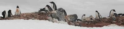
Met two researchers from Oceanites, a nonprofit research organization that specializes in counting penguins. The do a census of some of the penguin species at sample sites. They will have three researchers on board for this trip. According to them, any time we land where there are penguins, they will be running through penguin rookeries counting penguins.They will offer a briefing on their research sometime during the trip.


City Planning note: The main freeway through Santiago is mainly below the surface. In many places there is a linear park on top. In some places the river is on top. (not a big river but a VERY fast river.) What a great way to minimize the impact of a six-lane freeway.

Tuesday, to Tierra del Fuego and the ship. Wake-up at 5:00, quick breakfast, then to the airport for a charter flight to Ushuaia, Argentina. Tried again to sleep on the plane.

Bus ride through to outskirts of Ushuaia. Ushuaia’s population is about 50,000. Has some manufacturing but the largest employers are government (it is the capital of the provence) and tourism.

We Drive through Tera del Fuego national park and stop at the end of the road. Literally the end of the road. Argentina Highway 3 is the Trans=American Highway. So this is the end of a highway that starts in Alaska.

While Tierra del Fuego seems to have s climate similar to SE Alaska the Flora and Fauna are very different. No large mammals, the major species seems to be the Canadian Beaver--introduced as an attempt to start a fur industry around 1950. The industry didn’t work but the Beavers love it. No conifers. But a number of varieties of “False Birch” trees that are extremely slow growing.

We board a catamaran (motorized, not sail) for lunch and a ride through the Beagle Channel and back to Ushuaia to board our ship. The channel is named for the ship Charles Darwin was on. (The main reason for the catamaran trip was to give the ship crew time to clean the ship and get ready for us--the passengers from the previous trip just got off the ship thas morning.)

Saturday, November 07, 2009

Twin Cities Media Alliance Fall Forum

Title: Networking And The New Media Landscape: Reporting News, Building Community, Making Money
Sponsor: Twin Cities Media Alliance/ Twin Cities Daily Planet
Attendance: about 85--from across the political/ideological landscape
Twitter tag: #TCMA09

Keynote: The Twin Cities Media Ecosystem by Matt Thompson of Knight Foundation:

Three stages of media in the Twin Cities:
  • The Niche Media phase--lots of publications--from an early 20th century publication on grain milling that had correspondents in London and New York to a lot of papers written in the languages of the many new immigrants.
  • The Mass Media--the multiple daily newspapers that were in the Twin Cities merge into just two--one on the East side (St. Paul) and one on the West side (Minneapolis). National news is concentrated in a few "voices" (e.g. Walter Cronkite)
  • The Networked Media--Cross feeds--new curators--individuals select the sources we believe and share them, information is connected to other informations, sources connect to each other, news aggregation sites connect to each other, We have to talk about
Local media has to stop talking about the information we provide and start talking about the value we provide (this was really brought home to be during a site visit to TCMA by a local foundation last week).

First Panel (Reporting the News) Take Away:
Everyone is getting into news aggregation--from hyper local neighborhood sites to Minnesota Public Radio and WCCO TV (Local CBS). TC Daily Planet, while it was an early aggregator of community news (both ethnic and geographic communities), will be competing with more aggregators in the near future.

Keynote 2: Bruce Schneier, "Blogging, New Media and the Generation Gap"

Five key works for new media
  • Be Interesting--every page, every sentence, every article
  • Be Entertaining--it is no accident that many young people get their news from John Stewart. Rush Limbaugh knows he is an entertaining.
  • Be Engaging--(I would say "Be Community") people want to talk to each other. Communities can be geographical, topical. Community can be more important than news
  • Be available--there has to be an easy way to get to older content.
  • Be agile--you don't know what the new device or new platform will be tomorrow or next week. You don't know how new generations will use the Internet How the young will use the Internet will not just be different, it will be incomprehensible.
Bruce recommends checking out book "Free" by Kris (Sp???) Anderson (I wonder if I can literally check it out since this is happening in a library.)

In response to a question: "Net Neutrality can not fail. If it fails legally, there will be enough work arounds that it will eventually succeed. It is an important fight. It if fails, we will see a major set-back with a bunch of old media companies using the law to hand on to an old model. People fighting it will have a lot of technical tools--they just won't have the law on their side."

Second Panel (Building Community) Take Aways:
  • Building community is a lot of work (hey, it was actually acknowledged!)
  • While a couple years ago, no one site will be the "one site" for any specific community.
Third Panel (the hardest to get speakers to fill) "Making Money" Take Aways
  • www.bringmethenews.com is a for profit news site. (at least they hope to be profitable). No banner ads--rely on sponsored content. My question--Isn't sponsored content just another way to say "long form ad"
  • L3C funding model for funding=Low Profit Limited Liability Corporation. Primary aim is to further a social purpose. They are designed to attract capital to benefit the community. Good source for information--Americans for Community Development.
  • From the Uptake: "If anyone tells you they have funding and business models for media figured out--don't believe them."

Friday, November 06, 2009

Lunch--Nonprofit Mission and Excellence Awards

Nonprofit Excellence--large organization

Simpson Housing Services

Julie Manworren (ED of Simpson) “No man, woman or child should experience homelessness. We can end homelessness.”


Nonprofit Excellence--small organization

Dakota Woodlands (shelter for homeless families in a Twin Cities suburb).

Reyne Branchaud-Linsk (ED) “It is important to continue to help families after they find housing of their own.”


Responsive Philanthropy Nonprofit Mission Award

Carl and Eloise Pohlad Family Foundation

(The foundation actually increased their grants to nonprofits to help in the recession.)

A number of members of the family accepted the award.


Innovation Nonprofit Mission Award

CaringBridge


Advocacy Nonprofit Mission Award

National Alliance on Mental Illness of Minnesota

“Sometimes the best way to serve our clients is to teach them to advocate for themselves.”


Anti-Racism Initiative Nonprofit Mission Award

Clayton Jackson McGhie Memorial

Nonprofit Standards

Charities Review Council’s New Accountability Standards (7:45 AM)


First, a conference session starting at 7:45 AM? I think this only happens at nonprofit conferences.


Minnesota has this unique organization--the Charities Review Council that sets standards for nonprofit organizations. The organization has been around since the 1940s. They have a new set of accountability standards that was presented at this session. Overall headings include: Public Disclosure, Governance, Financial Activity, and Fundraising (a total of 27 separate standards. The most interesting part of the session was the question/discussion section. Being a shameless agitator, I raised my hand first:


The public disclosure section is all about transparency. My major problem with this section (overall it is a great section) is that it doesn’t require nonprofits to be proactive about communication. It is all passive (“Make the information available to the public’). There is no discussion about working to engage the community.


The data privacy standard only addresses donor privacy. It should also address client data privacy.


My major complaints are about the "Use of Funds" section in the standards on Financial Activity. (Really, about the percent of administrative cost that is allowed.):

  • First, it is better than it was. The text addresses the reality that administrative costs are important and valuable and that not all nonprofits will be the same.
  • It requires an explanation if the organization claims administrative costs of under 10%. This at least re-inforces the fact that not all administrative cost is bad.
  • It also allows a three year average of administrative costs. While this helps for major infrastructure projects like implementing a new database, it may not be enough. A three year average doesn't allow much for ongoing investment in non-capital infrastructure. However, it still sets percentage standards.
  • My major complaint is that the percentages don't work for a lot of organizations. For example, small nonprofits that rely on volunteers to provide services and have limited staff who manage the organization and coordinate the volunteers will have a high percentage of administrative costs--simply because its program costs are low (I actually kind of did a rant on this topic) (go here for a longer rant and a link to a great article from Fast Company about this)


Thoughts from the Minnesota Nonprofit and Foundation Conference

(This is going to be a series of shorter posts)


This conference is a day and a half--jointly put on by the Minnesota Council of Nonprofits and the Minnesota Council of Foundations.


Title: Transforming our Work: from Challenging Times to Hopeful Futures (The title seems to follow the standard nonprofit conference model” three words, colon, four to six words.) http://www.transformingourwork.org/


Attendance: 1800 nonprofit professionals, foundation staff persons, board members of foundations and nonprofits, and quite a few consultants (like me--looking for projects)


Facility:

St. Paul River Center convention center. Great layout, Great location. I found reasonably priced parking only a block away (RiverCenter municipal ramp across the street is OVER priced). But, no wifi on conference floor. YOu have to go downstairs to coffee shop to get wifi. What is this, 1990???


General Thoughts:

  • The organizers are allowing a lot of time for networking--that’s what I come to conferences for.
  • First sessions on Friday are at 7:45. AGGG. No private sector conference would start THAT early!
  • There is NO resource room where participants can leave literature for other attendees to pick up (this is usually a great source of material to plagiarize from--opps, I mean learn from.
  • Great networking--meeting a lot of old friends and new people. Ran out of business cards on the Thursday afternoon.
  • Wish there were more people from local foundations and at least some people from national foundations so they could learn a little about the real world of running a nonprofit and dealing with their requirements.
  • Really wish some government funders of nonprofits (e.g. counties that provide funding for human service nonprofits) were here to learn.