Tuesday, December 15, 2009

Getting Home

Short summary:

  • Four airports
  • Went through immigration control four times (Argentina exit, Chile entry and exit--without leaving the airport, US entry)
  • Customs twice (including an extensive check in Chile by the Agricultural Department)
  • Stood in 16 lines
  • Actually slept fairly well on red-eye from Santiago--was really tired.
  • Seven hour scheduled wait in Miami--but the flight was on time in spite of blizzard (Plane left Detroit before the blizzard hit that city)

Miscellaneous thoughts on trip:

  • It was an amazing trip
  • If I have to pick one highlight it would be the penguins--over a million penguins, seven species, surprisingly different behaviors. As one naturalist said, some penguin species are on speed, others are on quaaludes.
  • It was odd watching Neil Armstrong standing in line with the rest of us.
  • What species penguin is the open source mascot? (only geeks will understand this)
  • There are really 18 species of penguin--17 biological species plus Opus
  • From Ralf--the staff photographer for Lindblad--the more pixels you burn (pictures you take), the lower the cost of every picture on this trip.
  • This kind of trip is all about organizing the details and flexibility and Lindblad is expert at that. Major plan changes on this trip happened four times (you have to expect that with a three week trip to Antarctica) and everything went smoothly.
  • Got home to temperatures 20 degrees F BELOW the coldest we saw in Antarctica--we did go south for warmer weather--like Minnesotans typically do in winter.

The last day at sea: Neil Armstrong, Global Warming

Our last day at sea:

  • Got up late--9 AM--just in time to hear Neil Armstrong’s second presentation. He is obviously very tired about.
  • A second presentation by Neil Armstrong about exploration. About the first attempt to reach the north pole by air. Great presentation but he clearly is tired about talking about the moon (as anyone would be in his unique situation).
  • A presentation on logistics--have our luggage outside our door by 6:30 AM for transfer to the airport (a charter flight to Santiago)
  • A 90 minute presentation plus a half hour discussion on climate change. One of the naturalists gave a very science based presentation on the evidence for climate change and the evidence that is is caused by us. During the discussion period, a number of people who did believe the premise that humans are causing significant climate change raised specific questions about some very minor parts of his talk (e.g. the Nobel Prize for Al Gore, that a number of the companies that support climate change legislation have a vested economic interest in the legislation). A couple people commented that reducing the use of fossil based energy sources would not only reduce climate change but improve the efficiency of the US economy, reduce the US dependency on foreign energy supplies, and improve our security--the argument was that we should not require agreement on reasons when we can agree on the action for different reasons.

Oceanities

The executive director and two staff from Oceanities were on the ship for the whole voyage. Oceanities is a nonprofit organization that is conducting a multi-year biological site inventories at a variety of critical environmental sites around the Antarctica Peninsula. Oceanities is a small, independent research organization funded by foundations, individual contributions and the National Science Foundation. They are the only non-governmental research organization operating in Antarctica. More information about Oceanities is at their website at http://www.oceanites.org.


It’s been great having the Oceanities researchers onboard. Ron, the executive director gave one talk on their research that was very interesting. But more important, when they are not counting penguins and doing photo documentation of sites, they act as additional naturalists--very knowledgeable naturalists. (Lindblad/National Geographic provides logistics support by allowing the Oceanities researchers to use their cruises to access the sites.)

Some major points from Ron’s talk:

  • The Antarctic Peninsula warming 5 times faster than the average over the whole earth
  • Adelie and chinstrap penguin populations are rapidly dropping in the Antarctic Peninsula as the area warms. Since they rely on sea ice, as the area warms their range is shrinking as it moves south.
  • The gentoo Penguin population in the Antarctic Peninsula area is increasing. Since gentoo penguins’ food supply is in warmer water, their range is moving south as the climate warms.

Monday, December 07, 2009

Birds (but not penguins), tea and biscits, rats (not) and more penguins. Sunday, December 6

The morning landing is on the privately owned Carcass Island. (It was named after Lord and Lady Carcass. If I remember what one of the naturalists said correctly, they provided some funding for a 18th century research and survey expedition. What a bad name to be stuck with. It is owned by a sheep ranching family. But int he last few years, the bottom has fallen out of the wool industry (it can now cost more to sheer a sheep than you can get for the wool). The family now makes their living from landing fees for tourists (paid for by Lindblad). They have three things that get cruises to stop at their island--one really cool and two that are kind of just nice additions:

  • The most important reason is that the island has surprisingly remained rat-free. This means that it still has a great population of the many ground nesting birds--especially the song-bird varieties. It’s kind of surprising that the island has remained rat free because the family doesn’t require cruse ships to take any special precautions when landing. For some reason, for all the years that sheep, feed and supplies has been landed on the island, no rats have been hitchhikers. The birding on this island is amazing!
  • They’ve built a large restroom facility. This is the first place we’ve visited (other than Port Stanley) that has had restroom facilities.
  • They serve tea, biscuits (cookies) and cakes to the people who land. The variety of cookies is amazing.

One plentiful bird was the a local thrush that looks had behaves exactly like the North American robin (at least a faded robin--no red breast). It is in fact very closely related.


That afternoon, we visit New Island, the western most of the Falkland Islands. Again, a privately owned island, much of it was used for grazing sheep--the tussuc grass has been replaced by a European grazing grass.


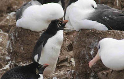
We land in a sheltered natural harbor and then hike across a narrow point to the northwestern side. On the hike, we see numerous kelp and upland geese. They have thrived since the sheep were removed--the love the grassy areas. The area we hiked to had been fenced off while sheep were here (to keep them from falling off a high cliff into the ocean.so there is still plenty of tussuc grass. The area below the clifts and along the edge are filled with nesting black browed albatross, Blue-eyed shags (a cormorant) and rock-hopper penguins. We hang out there for over two hours. Lots of “pixels are burned.”


The rock-hopper penguins are the smallest penguin--only about 16 inches tall and are related to the macaroni penguin. They seem to be able to hop up about 12 inches and down about 18 inches. It is amazing watching them move around. They are the first penguin we see that makes a more traditional nest--out of mud, grass and guano.


The albatross makes a rather high pedestal nest out of mud, grass and guano. There seem to be the clumsiest birds when landing--most times falling over in the process. To take off, they walk to the edge of the cliff, wait for a gust of wind and jump.


The blue-eyed cormorants have amazing blue eyes a beautiful blue-black feathers and bright orange tufts of feathers around their beak.


The Lindblad staff managed to make the last day on-shore a great climax.

Albatross, Rock Hoppers, Changeable weather. Saturday, December 5

This morning we’re at Steeple Jason Island. It is one of the chain of Jason chain of islands stretching 40 miles northeast of the main Falkland Islands. It is owned by a nonprofit that is starting to restore it. It is usually not included in cruises--even by Lindblad because of the difficult landing conditions. However, today the wind is right for a reasonable landing. We hike about two kilometers up a ridge. When we get over the ridge, we are treated to the world’s largest black-browed albatross colony, containing about 157,000 breading pairs (over 300,000 birds). The colony is over three miles long along the rocky beach. The number in the air is amazing. A few of us make our way through the tussuc grass mounds down to the edge of the colony. We end up right under the flight path of the albatross.


Nesting among the albatross are rock-hopper penguins. These are the smallest of the penguins we’ve seen. The lichens are amazing--orange, brown, red, green. Some really cool green lichen that forms ribbons.


At lunch we are at the same table as Melissa--one of the people from Oceanities. Her real job is working for Rathyon’s Antarctic Services division. They have the contract with the National Science Foundation to provide all the logistical support and manage the three US research stations on Antarctica as well as the two research ships. Melissa’s job there is project manager for research projects that work away from the three bases in tent camps. She takes vacation and leave to work with Oceanities in Antarctica. She gave us a feeling for the complexity of getting materials to the Antarctic bases for research.


That afternoon we land at Saunder’s Island. Landing was easy but as we walk toward the rock-hopper colony the wind picks up. Sand is blowing across the beach. I’d guess it was about 40 miles per hour. Then it gets cloudy and we’re in a driving sleet. The sleet lasts only about 10 minutes and the sun comes out. Wind is still strong but the sleet at least stopped the sand from blowing. Just another case of the weather changing very quickly and very often in the Falklands.


At sea, Port Stanley, Falkland Islands, Friday, December 4


After the morning at sea, we tie up to the industrial dock at Port Stanley at 1:30. We take the “two hour tour” option. Kind of looks like a retired Crockidle Dundee with a very dry British humor. “We don’t have a lot to show you in Stanley, so we have to show you everything.” Some interesting things about Port Stanley:

  • The capital and largest city in the Falklands--about 2500 population (total of about 3000 in all of the Falklands).
  • Much of the peat on the island is in common ownership--families have specific plots and can harvest peat for heating.
  • Peat is kind of soggy pre-coal. You have to let it dry before burning it.
  • No indigenous trees. But imported trees in Stanley and at the settlements ("settlements" appear to be the Falkland term for central buildings on a ranch.)
  • One garden had numerous gnomes. Gnomes show up at the post office with notes saying, please put me in the garden with my fellow gnomes. Our guide referred to it as the Port Stanley botanical garden.
  • The Falklands earn enough from fishing licenses to be self supporting except for defense.
  • As a self governing “overseas territory of the UK", they control most everything except foreign affairs and defense--both controlled by the UK government in London.
  • Most people in the Falklands work for the government.
  • A fair number of new houses--financed by the fisheries income.
  • Many houses and buildings brightly colored with brightly colored metal roofs. This really looks great against the landscape of the Falklands.


The weather changes by the minute here. Sleet followed by sunny skies, followed by stiff winds followed by calm, followed by a driving downpour, followed by sunny skies (in a period of four hours.


After the tour, we do some gift shopping in downtown Stanley with some on foot sight seeing. We end by going into the Global Tavern Pub. It appears half the ship also decided to stop at this pub.


As soon as we get onboard, we head off to tomorrow’s landing--in the far northwest of the Falkland Islands.

Friday, December 04, 2009

Photography tips from the Photography Department

It turns out that all of Lindblad’s trips to Antarctica include photography experts who are there to help the guests. It has been great asking both Flip Nicklin (the National Geographic photographer on board) and Ralf Hopkins (the Lindblad staff photographer on our trip) for advice and help. Besides the one-on-one help they provide, Ralph did a session in the lounge on Ten Tips to Improve Your Images. Here are some tips I really liked:

  1. Seeing the light: think about the direction of light (for example, sometimes it works great to have back-light or side-light. Sometimes light is too harsh. Sometimes there is too much contrast. Sometimes using fill-flash will help. “Find the best light and shot what’s in it.” For back-light, sometimes have the sun in the picture--just shoot at a high f-stop and pinch the sun with mountains or trees or rocks. Side-light can set up great reflections (e.g. the light in an animal’s eye.
  2. Choose the Right Lens. A murphy’s rule in photography: “No matter what lens you have on your camera for a specific situation, it is always the wrong lens.”
  3. Look for Color: “Vivid and saturated colors make your images pop.
  4. Show motion: Experiment with slow shutter speeds (e.g. 1/8 second for flowing water). Pan with moving objects--hopefully the object will be clear and the background will show a blur.

(From Ralph Lee Hopkins, RalphLeeHopkins.com)

Wednesday, December 02, 2009

At sea to the Falklands Wednesday, December 2, Thursday December 3.

At 1 AM a passenger is transferred aboard from another company’s cruise ship. He had broken his hip and we will be the fastest way to get him to a hospital in the Falklands (since that is our next stop). Our doctor does an evaluation and we end up leaving immediately for the Falklands to get him to the hospital as soon as possible (we had planed on one more stop on South Georgia this morning). According to the expedition leader, they have platted a course to avoid the worse weather--going between two weather systems.


We head to the northwest end of South Georgia and take a course west-south-west. We have a 40 knot (45 MPH) wind on our starboard with hugh ocean swells. I put on a sea-sickness transdermal patch at about 4 AM. Bev and I skip breakfast and sleep in--it is great to be able to sleep in and not miss anything.


Because of the rough seas--ten to twelve foot swells--we don’t have the typical buffet for lunch. The wait staff brings us our food.


Staff organizes an Antarctic/South Georgia Jeopardy game. We both pass


Thursday is more rough sees. I don’t feel bad about having to wear the sea-sickness patch--staff members are getting sea sick.

History day on South Georgia. Tuesday, December 1.


We start in Stromness Harbour--a whaling site that was in operation until the mid 1960s. It is also where Shackleton’s 36 hour hike from the other side of South Georgia finally ended. From here he got a steam powered whaler to go around South Georgia to pick up the men he left on the other side of the island. Since it was getting to be winter in Antarctica, it took him four tries to finally get to the men he left on Elephant Island.


South Georgia government prohibits approaching closer than 200 meters (2 football fields) to the old whaling station because the strong winds can pick off pieces of sheet metal from the old buildings and send them flying. (It seems to be an example of a little overly cautious British Government.) We get fairly close to the old station by zodiac. It has been taken over by fur and elephant seeds and sea birds. We then land and hike back from the beach for more nature. We have to land on a beach with lots of breeding fur seals. The keep the tourists in line and the fur seals in their place, they have set kayaks up to provide a corridor up the beach to an area where the fur seals are less numerous.


During lunch we head to Grytviken--again on the open sea during lunch but today isn’t as bad as Monday. The Norwegians started whaling at Grytviken in 1904 and it changed ownership a number of times--ending with a two year lease to a Japanese company that was trying to develop a market for frozen whale meat. They were not successful because most of the whales had already been killed. This is also where Sir Ernest Shackleton died of a massive heat attack at the start of an expedition he launched in the 1920s. He is grave is here and we visit it and toast him with a shot of rum. Steve (the naturalist who also specializes in history) gives Shackleton a great tribute. The passenger who is the trumpet player played Bramhs (spelling?) Lullaby at gravesite. I thought that was a strange choice but we learn at the wrap-up that it is the same song that was played on banjo by one of Shackleton’s crew at Shackleton’s funeral. There are a number of people on this trip who came specifically because they are Shackleton history buffs so this is a very significant stop for them.


The museum here includes a lot of information on Shackleton (including a recreation of the 23 foot lifeboat he used to sail sail the 800 miles from Elephant Island to here), information on whaling history and natural history. It also includes history of the Falkland war (Argentina invaded South Georgia and occupied the research station, government offices and old whaling station for about two weeks.) It is a really good small museum in the middle of nowhere. Much of this whaling station has

been torn down for safety but we are allowed to walk around the remaining buildings (which have been stabilized). Whaling ended here in 1965.


In the last few years of whaling they seem to have made use of much of the animal (not just the blubber for oil). Some of the pictures are pretty gruesome. It turns out that if you ate margarine in the 1950s or early 1960s, you were eating hydrogenated whale oil.


Evening wrap-up: Some great stories about the Shackleton expedition but the highlight is a presentation by the staff from the South Georgia government and the British Antarctic Research facility. Some interesting random facts:

  • To reduce their carbon footprint, the government/research station has re-commissioned an old hydro electric dam built by the Norwegians years ago. It now produces enough power for the research facility, government offices and museum--about 300 kilowatts. They just started using it a month ago so they haven’t used it through the winter but expect it to work year around--totally eliminating the need for diesel fuel for heating and electricity.
  • There is concern that the amount of krill in the ocean around South Georgia significantly dropped last year. The drop was caused by a shift in the location of the Antarctic Convergence (where the warm and cold oceans meet) to south of South Georgia. This resulted in warmer, less nutrient rich waters around the island. With the reduction in food, there has been a reduction in fur seals breading and the Gentoo penguins on South Georgia failed to raise chicks last year. This looks like a temporary situation, the Antarctic Convergence has moved back north and the penguins are mating this year. However, with climate change it may be happening more often than in the past.
  • The government actively manages the fishery to the territorial limit of 200 miles around South Georgia and the South Sandwich Islands. Commercial fishing licenses fund the enforcement that includes observers on all the fishing ships. They actively control the catch and the methods (e.g. bottom trawling is strictly prohibited). The South Georgia tooth fish (also known as Patagonian tooth fish, Antarctica sea bass and Chilean sea bass is certified by the Marine Stewardship Council as a sustainable, well regulated fishery (check for the marine council logo).

Hiking, rain, moss. Monday November 30

We are at Molke Harbour in Royal Bay--specifically because it is sheltered from strong northerly winds. But it is a wet, kind of miserable morning. Zodiac ride to shore in a 20 MPH wind (about 42 degrees F) with a drizzle and very cloudy skies. As we hike away from the beach, the wind calms down and the drizzle almost stops. Two reindeer herds, one with a large buck standing watch. We hike up a small river that is fed by melting snow. It’s surprising how far up the river the elephant seal weaners have come--especially considering that they can not lift themselves up on their flippers; they move more like maggots. The river isn’t very deep and the bed is about full of fist size and larger rough rocks. Moving down the river to get back to the sea must be really hard on the skin on their bellies.

There is a great variety of mosses and lichens on the hills.

During lunch it is very rough--the bow is pounding into the sea and spray is going as high as the bridge. A lot of people don’t finish their lunches and disappear into their cabins. Luckily, I had taken the sea-sickness medicine about a hour before we left the relative calm of Molke Harbor. But after a light lunch I also lay down in the cabin for a quick nap. That seems to be one of the best ways to avoid sea-sickness--just sleep through rough seas.


We get to Jason Harbor--again chosen mainly for being sheltered from the northerly wind. Bev decides to keep napping. We have to wind our way through the fur seal males--keeping our distance from all of them. It is a strange landscape--tussuc grass mounds that have been grazed very short by the reindeer with standing water between them. You have to step from one mound to the next to make your way back to higher ground. More reindeer, some Antarctic Terns that are unhappy with us, some molting king penguins standing in a middle green grass.